BIM-GIS, IoT, AND AR/VR SMART MAINTENANCE AND, MANAGEMENT OF ROAD NETWORK


Abstract :
The maintenance of road networks requires a huge amount of data about their previous maintenance history and current status. One of the very characteristics of information systems is geographic information is a geographic information system which suggests the appropriate way to handle it but access to that type of information is challenging because some data are still stored on paper, the database is out of date, managing older records and creating new records take much labor, field resources is expensive. Thus we need to make intelligent management and road maintenance infrastructure . Some new technologies have appeared in the last 5 years to solve some issues, some of the technologies are building information modeling, the Internet of Things, and virtual augmented reality.
Introduction :
Now smart cities are on the way from concept to reality. For cities to become smarter we need to continuously monitor infrastructure so as to allow real-time models to support policy decisions better this thing can be done in the old-fashioned way information and communication technology instead real-time monitoring provides us data which helps us in giving degradation status and making improvements accordingly. This way we can prevent many disasters by using real-time updates for our infrastructure parameters and elements for instance using a decision-making algorithm. Some effort has already been made by building infrastructure modeling and visual modeling systems to manage well the infrastructure using BIM the last twenty years this technology has helped us build infrastructure and also maintenance throughout our whole life so therefor we can use BIM for infrastructure management. BIM not only gives 3D modeling of infrastructure but also provides a huge amount of statistical and semantical data. On the other hand, GIS helps us to manage, visualize, analyze, and store spatial data. The GIS technology helps to see the real world by their grid so we can create real-world infrastructure. Where there elements are situated however it doesn’t give detailed indoor information which gives BIM. The IoT acts as a communicator between real or virtual objects so they can interact each other if they interact with each other if they are present in the same network. The IoT is facing a massive boom since all sorts of things can actively communicate which generates a huge amount of information. The main concept of virtual reality is to submerge the environment and augmented reality is computer-generated virtual objects overlapping the user’s real environment. The former concept allows people to explore experiences in a different environment other than reality with good information with accountability. Practical application potentials. We can say that the fall integration of the four mentioned technologies brings important advances regarding the management of the infrastructure. Here I will give you overview these technologies and identify the potential and advantages of integrating them together in the specific application domain of road infrastructure maintenance and management
On the integration of IoT , BIM, GIS:
There are lots of studies already done to integrate BIM and GIS with IoT technology. Isikdag proposed an infrastructure where IoT is used for gathering information and building BIM models and at the last information is exchanged to create a GIS model. IoT sensor provides geometric information about the state and the surroundings. The GIS database updates according to the message exchange from the IoT sensor with the help of GIS API. When any change happens in the element of an infrastructure then the appropriate triggers happen in the platform which updates data. Data visualization is also possible due to the GIS environment. Boyes presented a study on BIM and IoT integration. According to him, privacy is much more attention in the field of smart building and IoT, To achieve a holistic concept of the IoT infrastructure and smart bullying issues related to authentication, safety, privacy, security, and resilience should be properly addressed and taken into account. Nowadays with the advancement of technology every issue. The importance of technology doesn’t resolve that issue otherwise many users refuse to use new technology strategies centered on BIM to facilitate stakeholder communication and analyze stakeholder risk production. The study aims to enhance communication and reduce the risk of stakeholders. One of the proposed strategies by Withar was a framework to map offshore prefabrication processes allowing capturing of the information flow through those processes another strategy analyze data and make decisions through a data flow diagram. The BIM-centered strategy aims to integrate BIM and IoT sensors with the people participating in the information flow, therefore, the system can use real-time decision-making. A GIS-IoT integration to analyze environmental information in the city and ten compare and associate the data with chronic obstructive pulmonary disease symptom colleagues. The IoT sensors are used to gather information through GPS signals moreover these sensors also collect data about air pollution, humidity, and temperature. The analytical data of collected by IoT associated provides real-time monitoring of the user’s life. This helps us to study indeed how these diseases spread in city life. As IoT sensors can be placed everywhere and all smartphones have excellent GPS signals so we can implement that idea on large scales like big cities however some enhancements are required in the sensor interoperability three to their heterogeneity resulting in difficult use. Other authors led by C. Hu proposed a GIS-IoT integration to manage and develop water conservancy under risk situations such as flood and drought disasters. The system uses IoT sensors to gather information and store it in a GIS database. The type of rainfall and other meteorological data and it is cloud-based system allow all computation in a cloud environment. The system can be used on mobile devices with extraordinary performance. The general data can be virtualized on a map and the authors suggest the obtained results support that the GIS-IoT integration can promote a smarter way of managing the water and its conservancy however colleagues proposed an ontology aiming to support intelligent water sensing. Thus also provides detailed analyses for the optimization of the water network. This ontology relies on BIM and GIS and extends BIM technology. Industry foundation classes with operational concepts. Moreover, it integrates statistical data and real-time data. Their study encourages the use of IoT sensors real-time data update and semantic web approaches. This also allows water analysis and the management of the water network can be monitored more smartly accounting for real-time information. Bottaccioli along with other explorers. BIM-GIS-IoT integration suggested an approach capable of allowing real-time visualization of every consumption of one infrastructure and the evaluation of its performance also in simulation. The authors took into account real weather conditions. To solve the interoperability issue of IoT sensors due to their heterogeneity Author developed a web servicited-based middleware.Their system consists of cloud-based software that monitors models of the infrastructure. The IoT sensor, BIM, and GIS database are also integrated as well. The IoT can also be used to measure the environment and energy-related parameters of the infrastructures. This kind of integral allows the infrastructure manager to execute near real-time actions and efficiency performance, temperature, and analyze energy consumption among other performance metrics of the system. Baracho, Almedia, and Pereia analyzed the association of ontology with IoT and BIM in construction. They suggest that an ontology could represent objects and their relationship according to the IoT perspective. IoT only allows to gathering and communication of important environmental information where whereas BIM technology allows 3D modelling of infrastructure using an IoT database.They conclude that integration of BIM, and IoT ontology can bring important nobilities into the construction area. The use of IoT for real-time monitoring together with the use of GIS to provide sequential information on hospitals and the use of BIM to enable a complete digital modeling of hospital building are the ideas underlying the proposal presented by Peng and others. This system is very good for calculating real-time risk and deals with emergencies in the hospital. The BIM and GIS technologies are connected with data collected by IoT sensors. GIS provides sequential information about hospitals and BIM provides hospital management with the help of this it is possible to prioritize data handled by the system. The BIM-IoT integration which aims to analyze the senior’s equality of life was proposed by Rich and Park. Their system monitors people’s age using biomarker sensors connected with IoT and BIM technologies. The BIM stored data collected by IoT sensors. This method can replace the general quality of life survey used until very much smarter but this concept only focuses on indoor infrastructure with the context of quality of life evaluation. GIS could contribute to the analysis of the outdoors thus enhancing the measurement method. Norjou and Hashemipour proposed GIS and IoI integration to create a web map with information on power outages and correspondent economic loss estimation. Their system provides tools for decision-making and gives support to the disaster-prone area and other problems in the energy sector mapping the network and analyzing the best way of solving with minimum economic impact. All the system uses real-time data using IoT sensors. This system also uses cloud computing to embed other system components such as spatial databases and other web services including web map services. Teizer proposed BIM-IoT integration for operation management inside of the infrastructure during the construction it provides real time data. At first, infrastructure is planned so the field condition is already prepared we have just to retrieve the current condition. To accomplish that the system is based on cloud. The system also allows obtaining the localization of the user through a Bluetooth low-energy simple location tracking system developed by authors. The system promises a smarter way of construction planning and execution with almost injury-free construction management. A GIS-IoT integration target to calculate the path with more available medical centers is discussed by Almobaideen and others. The study helps to find a way according to the closest medical centers open in the city. The path distance may not be the shortest one through. The itinerary will have the highest number of medical centers from the starting point to the ending point. This study mainly targets people with health problems nonetheless any person cloud see it. This system also gathers information using IoT sensors such as blood pressure and GPS signals of mobile devices. This information helps to monitor and calculate the path with medical centers specialized in treating the user’s illness. This type of study helps people in healthcare specially when they visit a different place and don’t have a proper idea about that place Zhong and his teammates a BIM-IoT integration to connect and share all the information with the stakeholders and also to add more dimensions to the BIM models such as cost estimation and duration schedule. The system has application to the prefabricated construction and gives the desired. Visibility and traceability to better monitor the status the progress and the estimated cost of the project in real time. The IoT sensors are used to gather information about the construction progress, resource consumption, and worker assignment information about the project status and can make decisions according to the current status. As we already know by using the IoT sensor managers make very good decisions and maintenance of infrastructure in general. This process also has many flaws and authors are concerned about that. The privacy issue and security concerns are one of the major flaws of using IoT. Even if any IoT sensor layer takes any wrong information then the produced output will be misleading which has consequences of making bad decisions.
On the integration with AR/VR BIM, GIS, IoT :
Past years may studies did the integration of AR/VR with BIM, GIS, and IoT. Wang and his colleagues proposed the integration of BIM-AR. This system aims to show hidden data of any construction by enabling an AR system. In this way all the users have real time data and give feed back to BIM to update Authors highlighted some points
Independency of works of every worker.
Spatial site layout collision management where some conflicts can arrive due to the workspace loucy placement.
Digital to physical link where the designing and planning tasks, work essentially with information
Project control where the schedule can grow due to design changes or errors
Material tracking and management where the delivery planning of the material cloud has problems.
Virtualization in the time of production where the interface cloud is challenging to use L V and collaborator proposed a GIS-IoT web VR integration aims to analyze the city and also have a visual integration in a virtual environment.
This system is also able to analyze spatial analysis and the virtualization of spatial information in 3D. Furthermore, it provides consistent external access to each model. The ability to monitor and visualize the real-time status of a city leverages a smarter way to control our city. The author’s aim in developing this system is to improve environmental protection and to foster awareness the public safety the management and the maintenance of the infrastructure with this work they wanted to promote greener environments .3D multi-scaling modeling and the development of collaborative platform approach to improve the digital 3D planning of infrastructure through BIM-GIS integration and described by Breunig and colleagues. They developed a mobile AR system to overlay with the related real-time information. This AR embedded uses mapping and image-based localization to estimate the pose of the camera and user. This type of system can help the construction of subway track infrastructures providing specialized and specific information about an infrastructure’s elements in all phases of the project’s left-cycle. E-Patti, A. Mollame proposes a BIM-IoT-AR integration. Their system is an Android-based application that enables access to the BIM-IoT integrated data and management in an AR environment. QR codes were used as markers to the AR recognition of which infrastructure appears in the scene to overcome IoT sensors interoperability issues created middleware layer so therefore it is possible to access such as temperature and energy consumption and integrate them with the BIM models. Through this integration, the users can leave the desktop and have local access to the infrastructure elements information through the AR environment. Moreover, the user has a better perception of the environmental parameters of the infrastructure. Luchetti led with others in the study describing GIS-IoT AR integration to facilitate decisions about unexpected events such as natural disasters. Prevention and monitoring of natural disasters are the most important aspects concerning human lives. Their system gathers information from all social media and social networks and also analyses it. The data which is gathered is geo-referenced and Twitter was used in their study. They developed a mobile application allowing for the visualization of information in an AR environment with which it is possible to get information about an event just by pointing the mobile device camera at this system presenting events with texts and maps.
As I discussed AR/VR integration brings forward many probabilities for implementation of smarter solutions to support infrastructure management and maintenance by giving hidden inheritance data of infrastructure elements, it is possible to better understand the
user tasks and even to give better feedback both to the system and to the user. Examples of such hidden information in configuration parameters, the history of maintenance operation performance upon that element the cost of that element with the help of mobile devices and applications retrieving the information in loco and thanks to the IoT integrations displaying and updating information in real-time are examples of tasks that become possible through approaches
Overview:
The integration of technologies BIM-GIS-IoT-AR/VR technology allow all types of data to be generated and analyzed potentially accessible and usable in real time anywhere. Thus it is possible to monitor
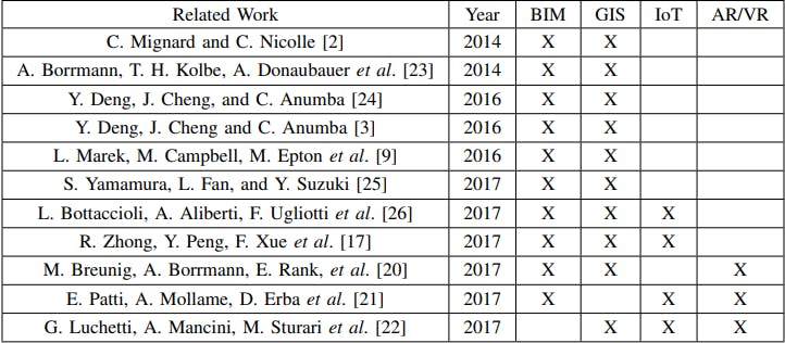
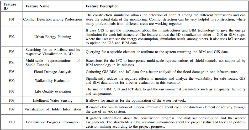
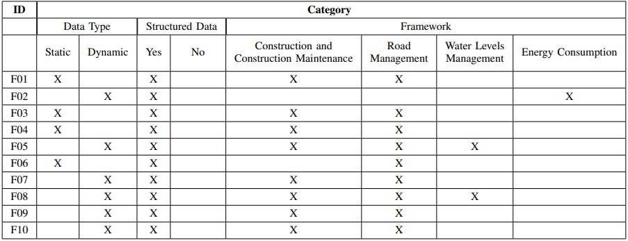
all steps in the management and maintenance of infrastructure in a smarter way. Moreover, such integration brings about important advances in self-organized resilient, which are more sustainable and need less energy in all their processes. The table summaries technologies and also shows such technologies are combined and used over the years the paradigm shift is notorious suggesting a trend towards the integration of the four technologies, even though the future of these technologies is still very long only the most successful studies with the highest relevance to the management and maintenance of road infrastructure are shown in the table. In this context most relevant technology is monitoring software by providing us external and internal parameters to aid decision making besides the publications year, column mark with an “x” the technologies used in each of the studies. An in-depth analysis of the selected studies allowed for the identification of the main features discussed in each work represented the main aspects of the problems. The authors try to tackle this through different integration approaches. The next table provides a brief explanation of each one which helps us to identify which of the selected studies were most significant to the specific domain of maintenance of road infrastructure we also grouped identified features into categories so that it is possible to understand how each study as related to others converting similar features and proposing equivalent approaches in their respective solutions. Table 3 lists the features discussed in the analyzed studies and groups them into categories
Data type
Weather data was structured or not
The type of framework proposed
An “x” identifies in which categories each of the features falls. Although all the discussed methods have awesome results the use of IoT is still a matter of concern because security privacy and interoperability and critical issues. The integration of IoT technology with BIM, and GIS offers much more scope for the improvement of cities but is still preliminary. BIM and GIS technology is in their mature phase but IoT is still evolving. There are some studies associated with all issues of IoT sensors. The GIS and AR integration of technology can pose many challenges to the current geo position.AR geolocation is error-prone in positioning virtual objects. The system can identify one infrastructure at the wrong place or even at the location where another infrastructure is. This type of error can give a really poor experience to the user in an AR environment. The same situation can occur using IoT and AR- technologies in the same integration. If the IoT sensor gives some wrong output and if AR displays that in our infrastructure. A tradeoff between the improvement expected for the cities and the reliability of the functionalities must be reached. On the other side, BIM-GIS integration has a strong life in research. BIM and GIS are very similar but they also have some critical differences. 3D designing and modeling are being used in BIM technology but GIS is more appropriate for characters of real-world objects on the other hand BIM is more focused on the life cycle of an object that even doesn’t exist in the real world. Moreover, they are focused on different geometric representations the only ones used by both technologies but their background is very different this is one of the most significant limitation and challenges for their integration potentially can lead to huge data loss
Conclusion :
The integration of AR/VR, IoT, GIS, and BIM seems very potential and very promising and have much potentially for the
of a fully integrated perspective encompassing all of those still faces challenges. The integration of BIM, GIS, and IoT also has the same problems as BIM-GIS integration and is also encountered by attempts involving IoT technologies. This time IoT is used all over the world however there remain main issues like privacy and security. Despite all problems, IoT proved already that it can offer a very important contribution to the management of infrastructure. The integration of three or four technologies is very common in the modern era. Integration of AR/VR allows us to display all hidden information about an infrastructure is a very big improvement in the construction and management sector. If we use mobile devices we can interact with the AR environment and consult data anywhere. Improvement is very necessary for AR/VR technology, especially regarding user tracking and localization which is still very coarse. We can predict a considerable improvement in management and maintenance through the combination of these four technologies. BIM and GIS integration based on huge data streaming from IoT, we can have access or real time information about both door and outside of the infrastructure. AR/VR technologies allow us to interact and leverage accessibility to geographical information stored on GIS platforms and services accessible remotely through mobile applications. Such technologies alone already yield and deal with an enormous amount of information. Certainly has the potential to foster the cities of the future.
FOR MORE UPCOMMING CONTENT YOU CAN FOLLOW ME ON HASHNODE